Krzemień - Bieszczady National Park
No weather data
0.0 /5
Number of ratings: 0
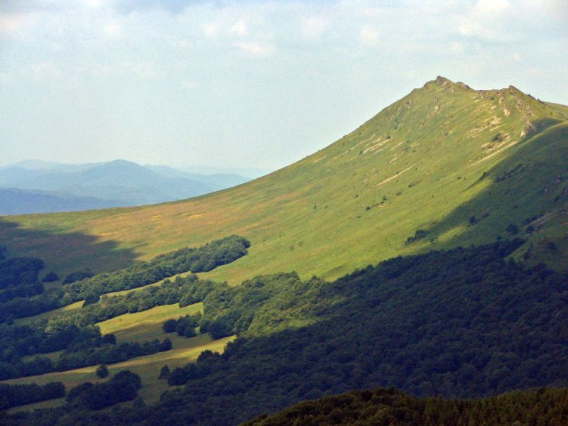
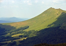
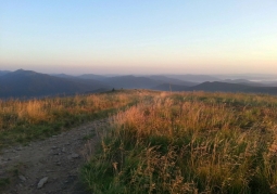
It is the second highest peak of the Polish Bieszczady Mountains and the entire Western Bieszczady Mountains, measuring 1335 m a.s.l. It is located in the central part of the Tarnica and Halicz groups, in the połonin band. Through its ridge stretching from northwest to southeast, numerous rocks are formed, forming the shape of a comb. The current name of Krzemień mountain comes from the word "comb" distorted by Austrian cartographers. From the highest point of the massif, located in the central part of it, the ridge diverges northeastwards towards Bukowy Berda separated by a shallow pass. However, to the south-west, another ridge runs, through the deep Goprowska Pass connecting Krzemień with the Tarnica and Wide Wierch massif. A few dozen meters from the top of the summit runs the blue trail (from Biała to Grybów), which from Goprowska Pass leads steeply upwards, reaching the ridge west of the summit, then heading through the pass (1268 m a.s.l.) to Bukowe Berdo. Access to the summit of Krzemień is, however, prohibited by the regulations of the Bieszczady National Park. From the summit of Krzemień you can see, among others, Tarnica with Broad Peak, Połonina Caryńska, Bukowe Berdo, the upper San valley, Halicz with Rozsypaniec, as well as the Sanocko-Turczańskie and Ukrainian Bieszczady ranges. The areas of the massif are covered with interesting flora, rare plant species such as rock sedge, sedge sedge, eastern Carpathian pea, or thyme plague grow here.
Komentarze
No results
Nearby places
Kopa Bukowska - Bieszczady National Park
Category: Peaks and valleysThe peak in the Western Bieszczady Mountains, one of the highest in this region, is 1320 m a.s.l. The massif is located in the mountain pastures, in a ridge stretching from Krzemień to Halicz. Kopa Bukowska is...
2 km
Tarnica - Bieszczady National Park
Category: Peaks and valleysTarnica is the highest peak of the Polish Bieszczady and Podkarpackie voivodship, rising at the end of the Połonin range, in the so-called Tarnica and Halicz nests. It belongs to the Crown of Polish Mountains.
2 km
Szeroki Wierch - Bieszczady National Park
Category: Peaks and valleysSzeroki Wierch is the western edge of the Tarnica group, it is separated from its highest peak by a small pass (1275 m a.s.l.). It is an elongated ridge covered with pastonia, with four culminations: 1243, 1268, 1293...
2 km

Bukowe Berdo - Bieszczady National Park
Category: Peaks and valleysMountain massif in the form of an elongated range with three peak culminations. It is characterized by a large presence of sandstone rocks. The high parts include polonina. The southwest slope descends into the...
3 km

Nearby places
Kopa Bukowska - Bieszczady National Park
Category: Peaks and valleysThe peak in the Western Bieszczady Mountains, one of the highest in this region, is 1320 m a.s.l. The massif is located in the mountain pastures, in a ridge stretching from Krzemień to Halicz. Kopa Bukowska is...
2 km
Tarnica - Bieszczady National Park
Category: Peaks and valleysTarnica is the highest peak of the Polish Bieszczady and Podkarpackie voivodship, rising at the end of the Połonin range, in the so-called Tarnica and Halicz nests. It belongs to the Crown of Polish Mountains.
2 km
Szeroki Wierch - Bieszczady National Park
Category: Peaks and valleysSzeroki Wierch is the western edge of the Tarnica group, it is separated from its highest peak by a small pass (1275 m a.s.l.). It is an elongated ridge covered with pastonia, with four culminations: 1243, 1268, 1293...
2 km
Bukowe Berdo - Bieszczady National Park
Category: Peaks and valleysMountain massif in the form of an elongated range with three peak culminations. It is characterized by a large presence of sandstone rocks. The high parts include polonina. The southwest slope descends into the...
3 km